In recent articles we have looked at rainfall and there is still more to discuss. This article changes tack to look at tropical cyclones, prompted by the recent US landfall of Harvey and Irma along with questions from readers about attribution and the future.
It might be surprising to find the following statement from leading climate scientists (Kevin Walsh and many co-authors in 2015):
At present, there is no climate theory that can predict the formation rate of tropical cyclones from the mean climate state.
The subject gets a little involved so let’s dig into a few papers. First from Gabriel Vecchi and some co-authors in 2008 in the journal Science. The paper is very brief and essentially raises one question – has the recent rise in total Atlantic cyclone intensity been a result of increases in absolute sea surface temperature (SST) or relative sea surface temperature:
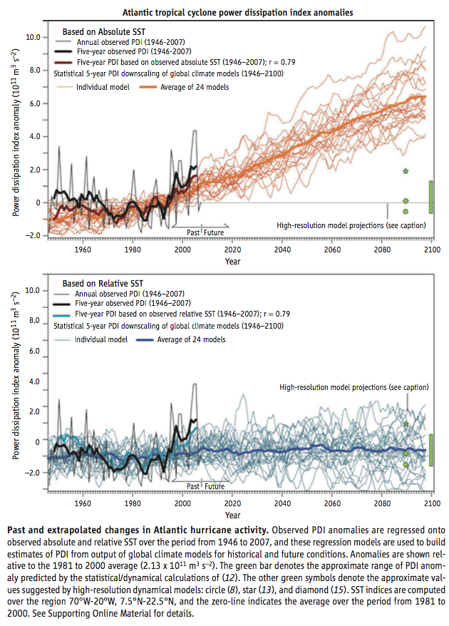
From Vecchi et al 2008
Figure 1
The top graph (above) shows a correlation of 0.79 between SST and PDI (power dissipation index). The bottom graph shows a correlation of 0.79 between relative SST (local sea surface temperature minus the average tropical sea surface temperature) and PDI.
With more CO2 in the atmosphere from burning fossil fuels we expect a warmer SST in the tropical Atlantic in 2100 than today. But we don’t expect the tropical Atlantic to warm faster than the tropics in general.
If cyclone intensity is dependent on local SST we expect more cyclones, or more powerful cyclones. If cyclone intensity is dependent on relative SST we expect no increase in cyclones. This is because climate models predict warmer SSTs in the future but not warmer Atlantic SSTs than the tropics. The paper also shows a few high resolution models – green symbols – sitting close to the zero change line.
Now predicting tropical cyclones with GCMs has a fundamental issue – the scale of a modern high resolution GCM is around 100km. But cyclone prediction requires a higher resolution due to their relatively small size.
Thomas Knutson and co-authors (including the great Isaac Held) produced a 2007 paper with an interesting method (of course, the idea is not at all new). They input actual meteorological data (i.e. real history from NCEP reanalysis) into a high resolution model which covered just the Atlantic region. Their aim was to see how well this model could reproduce tropical storms. There are some technicalities to the model – the output is constantly “nudged” back towards the actual climatology and out at the boundaries of the model we can’t expect good simulation results. The model resolution is 18km.
The main question addressed here is the following: Assuming one has essentially perfect knowledge of large-scale atmospheric conditions in the Atlantic over time, how well can one then simulate past variations in Atlantic hurricane activity using a dynamical model?
They comment that the cause of the recent (at that time) upswing in hurricane activity “remains unresolved”. (Of course, fast forward to 2016, prior to the recent two large landfall hurricanes, and the overall activity is at a 1970 low. In early 2018, this may be revised again..).
Two interesting graphs emerge. First an excellent match between model and observations for overall frequency year on year:
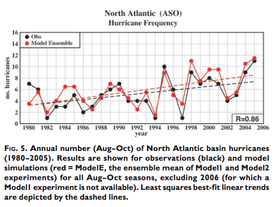
From Knutson et al 2007
Figure 2
Second, an inability to predict the most intense hurricanes. The black dots are observations, the red dots are simulations from the model. The vertical axis, a little difficult to read, is SLP, or sea level pressure:
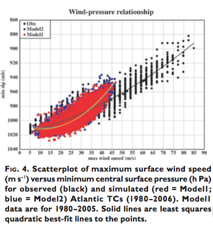
From Knutson et al 2007
Figure 3
These results are a common theme of many papers – inputting the historical climatological data into a model we can get some decent results on year to year variation in tropical cyclones. But models under-predict the most intense cyclones (hurricanes).
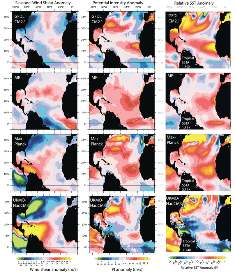
Here is Morris Bender and co-authors (including Thomas Knutson, Gabriel Vecchi – a frequent author or co-author in this genre, and of course Isaac Held) from 2010:
Some statistical analyses suggest a link between warmer Atlantic SSTs and increased hurricane activity, although other studies contend that the spatial structure of the SST change may be a more important control on tropical cyclone frequency and intensity. A few studies suggest that greenhouse warming has already produced a substantial rise in Atlantic tropical cyclone activity, but others question that conclusion.
This is a very typical introduction in papers on this topic. I note in passing this is a huge blow to the idea that climate scientists only ever introduce more certainty and alarm on the harm from future CO2 emissions. They don’t. However, it is also true that some climate scientists believe that recent events have been accentuated due to the last century of fossil fuel burning and these perspectives might be reported in the media. I try to ignore the media and that is my recommendation to readers on just about all subjects except essential ones like the weather and celebrity news.
This paper used a weather prediction model starting a few days before each storm to predict the outcome. If you understand the idea behind Knutson 2007 then this is just one step further – a few days prior to the emergence of an intense storm, input the actual climate data into a high resolution model and see how well the high res model predicts the observations. They also used projected future climates from CMIP3 models (note 1).
In the set of graphs below there are three points I want to highlight – and you probably need to click on the graph to enlarge it.
First, in graph B, “Zetac” is the model used by Knutson et al 2007, whereas GFDL is the weather prediction model getting better results in this paper – you can see that observations and the GFDL are pretty close in the maximum wind speed distribution. Second, the climate change predictions in E show that predictions of the future show an overall reduction in frequency of tropical storms, but an increase in the frequency of storms with the highest wind speeds – this is a common theme in papers from this genre. Third, in graph F, the results (from the weather prediction model) fed by different GCMs for future climate show quite different distributions. For example, the UKMO model produces a distribution of future wind speeds that is lower than current values.
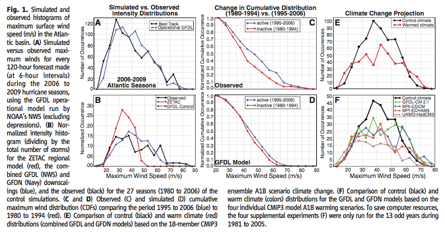
From Bender et al 2010
Figure 4 – Click to enlarge
In this graph (S3 from the Supplementary data) we see graphs of the difference between future projected climatologies and current climatologies for three relevant parameters for each of the four different models shown in graph F in the figure above:
From Bender et al 2010
Figure 5 – Click to enlarge
This illustrates that different projected future climatologies, which all show increased SST in the Atlantic region, generate quite different hurricane intensities. The paper suggests that the reduction in wind shear in the UKMO model produces a lower frequency of higher intensity hurricanes.
Conclusion
This article illustrates that feeding higher resolution models with current data can generate realistic cyclone data in some aspects, but less so in other aspects. As we increase the model resolution we can get even better results – but this is dependent on inputting the correct climate data. As we look towards 2100 the questions are – How realistic is the future climate data? How does that affect projections of hurricane frequencies and intensities?
Articles in this Series
Impacts – II – GHG Emissions Projections: SRES and RCP
Impacts – III – Population in 2100
Impacts – IV – Temperature Projections and Probabilities
Impacts – V – Climate change is already causing worsening storms, floods and droughts
Impacts – VI – Sea Level Rise 1
Impacts – VII – Sea Level 2 – Uncertainty
Impacts – VIII – Sea level 3 – USA
Impacts – IX – Sea Level 4 – Sinking Megacities
Impacts – X – Sea Level Rise 5 – Bangladesh
References
Hurricanes and climate: the US CLIVAR working group on hurricanes, American Meteorological Society, Kevin Walsh et al (2015) – free paper
Whither Hurricane Activity? Gabriel A Vecchi, Kyle L Swanson & Brian J. Soden, Science (2008) – free paper
Simulation of the Recent Multidecadal Increase of Atlantic Hurricane Activity Using an 18-km-Grid Regional Model, Thomas Knutson et al, American Meteorological Society, (2007) – free paper
Modeled Impact of Anthropogenic Warming on the Frequency of Intense Atlantic Hurricanes, Morris A Bender et al, Science (2010) – free paper
Notes
Note 1: The scenario is A1B, which is similar to RCP6 – that is, an approximate doubling of CO2 by the end of the century. The simulations came from the CMIP3 suite of model results.


