Feeds:
Posts
Comments

Archive for January, 2014

In previous posts we have seen – and critiqued – ideas about the causes of ice age inception and ice age termination being due to high latitude insolation. These ideas are known under the banner of “Milankovitch forcing”. Mostly I’ve presented the concept by plotting insolation data at particular latitudes, in one form or another. The insolation at different latitudes depends on obliquity and precession (as well as eccentricity).

Obliquity is the tilt of the earth’s axis – which varies over about 40,000 year cycles. Precession is the movement of point of closest approach (perihelion) and how it coincides with northern hemisphere summer – this varies over about a 20,000 year cycle. The effect of precession is modified by the eccentricity of the earth’s axis – which varies over a 100,000 year cycle.

If the earth’s orbit was a perfect circle (eccentricity = 0) then “precession” would have no effect, because the earth would be a constant distance from the sun. As eccentricity increases the impact of precession gets bigger.

How to understand these ideas better?

Peter Huybers has a nice explanation and presentation of obliquity and precession in his 2007 paper, along with some very interesting ideas that we will follow up in a later article.

The top graph shows the average insolation value by latitude and day of the year (over 2M years). The second graph shows the anomaly compared with the average at times of maximum obliquity. The third graph shows the anomaly compared with the average at times of maximum precession. The graphs to the right show the annual average of these values:

From Huybers (2007)

From Huybers (2007)

Figure 1

We can see immediately that times of maximum precession (bottom graph) have very little impact on annual averages (the right side graph). This is because the increase in, say, the summer/autumn, are cancelled out by the corresponding decreases in the spring.

But we can also see that times of maximum obliquity (middle graph) DO impact on annual averages (right side graph). Total energy is shifted to the poles from the tropics .

I was trying, not very effectively, to explain some of this in (too many graphs) in Part Five – Obliquity & Precession Changes.

Here is another way to look at this concept. For the last 500 kyrs, I plotted out obliquity and precession modified by eccentricity (e sin w) in the top graph, and in the bottom graph the annual anomaly by latitude and through time. WordPress kind of forces everything into 500 pixel wide graphs which doesn’t help too much. So click on it to get the HD version:

Obliquity-Precession-Annual-insolation-anomaly-last-500ka-499px

Figure 2 – Click to Expand

It is easy to see that the 40,000 year obliquity cycles correspond to high latitude (north & south) anomalies, which last for considerable periods. When obliquity is high, the northern and southern high latitude regions have an increase in annual average insolation. When obliquity is low, there is a decrease. If we look at the precession we don’t see a corresponding change in the annual average (because one season’s increase mostly cancels out the other season’s decrease).

Huybers’ paper has a lot more to it than that, and I recommend reading it. He has a 2M yr global proxy database, that isn’t dependent on “orbital tuning” (note 1) and an interesting explanation and demonstration for obliquity as the dominant factor in “pacing” the ice ages. We will come back to his ideas.

In the meantime, I’ve been collecting various data sources. One big challenge in understanding ice ages is that the graphs in the various papers don’t allow you to zoom in on the period of interest. I thought I could help to fix that by providing the data  – and comparing the data – in High Definition instead of snapshots of 800,000 years on half the width of a standard pdf. It’s a work in progress..

The top graph (below) has two versions of temperature proxy. One is Huyber’s global proxy for ice volume (δ18O) from deep ocean cores, while the other is the local proxy for temperature (δD) from Dome C core from Antarctica (75°S). This location is generally known as EDC, i.e., EPICA Dome C. The two datasets are laid out on their own timescales (more on timescales below):

EDC-and-Huybers-Proxy-CO2-CH4-Obliquity-last-500kyrs-499px

Figure 3 – Click to Expand

The middle graph has CO2 and CH4 from Dome C. It’s amazing how tightly CO2 and CH4 are linked to the temperature proxies and to each other. (The CO2 data comes from Lüthi et al 2008, and the CH4 data from Loulergue et al 2008).

The bottom graph has obliquity and annual insolation anomaly area-averaged over 70ºS-90ºS. Because we are looking at annual insolation anomaly this value is completely in phase with obliquity.

Why are the two datasets on the top graph out of alignment? I don’t know the full answer to this yet. Obviously the lag from the atmosphere to the deep ocean is part of the explanation.

Here is a 500 kyr comparison of LR04 (Lisiecki & Raymo 2005) and Huybers’ dataset – both deep ocean cores – but LR04 uses ‘orbital tuning’. The second graph has obliquity & precession (modified by eccentricity). The third graph has EDC from Antarctica:

LR04-Huybers-EDC-Obliquity-Precession-last-500kyrs-499px

Figure 4 – Click to Expand

Now we zoom in on the last 150 kyrs with two Antarctic cores on the top graph and NGRIP (North Greenland) on the bottom graph:

EDC-EDML-NGRIP-Obliquity-Prec-last-150kyrs-499px

Figure 5 – Click to Expand

Here we see EDML (high resolution Antarctic core) compared with NGRIP (Greenland) over the last 150 kyrs (NGRIP only goes back to 123 kyrs) plus CO2 & CH4 from EDC – once again, the tight correspondence of CO2 and CH4 with the temperature records from both polar regions is amazing:

EDML-NGRIP-CO2-CH4-last-150kyrs-499px

Figure 6 – Click to Expand

The comparison and linking of “abrupt climate change” in Greenland and Antarctic has been covered in EPICA 2006 (note the timescale is in the opposite direction to the graphs above):

from EPICA 2006

from EPICA 2006

Figure 7 – Click to Expand

Timescales

As most papers acknowledge, providing data on the most accurate “assumption free” timescales is the Holy Grail of ice age analysis. However, there are no assumption-free timescales. But lots of progress has been made.

Huybers’ timescale is based primarily on a) a sedimentation model, b) tying together the various identified inception & termination points for each of the proxies, c) the independently dated Brunhes- Matuyama reversal at 780,000 years ago.

The EDC (EPICA Dome ‘C’) timescale is based on a variety of age markers:

  • for the first 50 kyrs by tying the data to Greenland (via high resolution CH4 in both records) which can be layer counted because of much higher precipitation
  • volcanic eruptions
  • 10Be events which can be independently dated
  • ice flow models – how ice flows and compresses under pressure
  • finally, “orbital tuning”

EDC2 was the timescale on which the data was presented in the seminal 2004 EPICA paper. This 2004 paper presented the EDC core going back over 800 kyrs (previously the Vostok core was the longest, going back 400 kyrs). The EPICA 2006 paper was the Dronning Maud Land Core (EDML) which covered a shorter time (150 kyrs) but at higher resolution, allowing a better matchup between Antarctica and Greenland. This introduced the improved EDC3 timescale.

In a technical paper on dating, Parannin et al 2007 show the differences between EDC3 and EDC2 and also between EDC3 and LR04.

Parennin-2007-EDC3-timescale-fig3-499px

Figure 8 – Click to Expand

So if you have data, you need to understand the timescale it is plotted on.

I have the EDC3 timescale in terms of depth so next I’ll convert the EDC temperature proxy (δD) on EDC2 to EDC3 time. I also have dust vs depth for the EDC core – another fascinating variable that is about 25 times stronger during peak glacials compared with interglacials – this needs converting to the EDC3 timescale. Other data includes some other atmospheric chemical components. Then I have NGRIP data (North Greenland) going back 123,000 years but on the original 2004 timescale, and it has been relaid onto GICC05 timescale (still to find).

Very recently (mid 2013) a new Antarctic timescale was proposed – AICC2012 – which brings all of the Antarctic ice cores onto one common timescale.  See references below.

Matlab

Calling Matlab gurus – plotting many items onto one graph has some benefits. Matlab is an excellent tool but I haven’t yet figured out how to plot lots of data onto the same graph. If multiple data sources have the same x-series data and a similar y-range there is no problem. If I have two data sources with similar x values (but different x-series data) and completely different y values I can use plotyy. How about if I have five datasources, each with different but similar x-series and different y-values. How do I plot them on one graph, and display the multiple y-axes (easily)?

Conclusion

This article was intended to highlight obliquity and precession in a different and hopefully more useful way. And to begin to present some data in high resolution.

Articles in the Series

Part One – An introduction

Part Two – Lorenz – one point of view from the exceptional E.N. Lorenz

Part Three – Hays, Imbrie & Shackleton – how everyone got onto the Milankovitch theory

Part Four – Understanding Orbits, Seasons and Stuff – how the wobbles and movements of the earth’s orbit affect incoming solar radiation

Part Five – Obliquity & Precession Changes – and in a bit more detail

Part Six – “Hypotheses Abound” – lots of different theories that confusingly go by the same name

Part Seven – GCM I – early work with climate models to try and get “perennial snow cover” at high latitudes to start an ice age around 116,000 years ago

Part Seven and a Half – Mindmap – my mind map at that time, with many of the papers I have been reviewing and categorizing plus key extracts from those papers

Part Eight – GCM II – more recent work from the “noughties” – GCM results plus EMIC (earth models of intermediate complexity) again trying to produce perennial snow cover

Part Nine – GCM III – very recent work from 2012, a full GCM, with reduced spatial resolution and speeding up external forcings by a factors of 10, modeling the last 120 kyrs

Part Ten – GCM IV – very recent work from 2012, a high resolution GCM called CCSM4, producing glacial inception at 115 kyrs

Pop Quiz: End of An Ice Age – a chance for people to test their ideas about whether solar insolation is the factor that ended the last ice age

Eleven – End of the Last Ice age – latest data showing relationship between Southern Hemisphere temperatures, global temperatures and CO2

Twelve – GCM V – Ice Age Termination – very recent work from He et al 2013, using a high resolution GCM (CCSM3) to analyze the end of the last ice age and the complex link between Antarctic and Greenland

Thirteen – Terminator II – looking at the date of Termination II, the end of the penultimate ice age – and implications for the cause of Termination II

Fifteen – Roe vs Huybers – reviewing In Defence of Milankovitch, by Gerard Roe

Sixteen – Roe vs Huybers II – remapping a deep ocean core dataset and updating the previous article

Seventeen – Proxies under Water I – explaining the isotopic proxies and what they actually measure

Eighteen – “Probably Nonlinearity” of Unknown Origin – what is believed and what is put forward as evidence for the theory that ice age terminations were caused by orbital changes

Nineteen – Ice Sheet Models I – looking at the state of ice sheet models

References

Glacial variability over the last two million years: an extended depth-derived agemodel, continuous obliquity pacing, and the Pleistocene progression, Peter Huybers, Quaternary Science Reviews (2007) – free paper

Eight glacial cycles from an Antarctic ice core, EPICA community members, Nature (2004) – free paper

One-to-one coupling of glacial climate variability in Greenland and Antarctica,  EPICA Community Members, Nature (2006) – free paper

High-resolution carbon dioxide concentration record 650,000–800,000 years before present, Lüthi et al, Nature (2008)

Orbital and millennial-scale features of atmospheric CH4 over the past 800,000 years, Loulergue et al, Nature (2008)

A Pliocene-Pleistocene stack of 57 globally distributed benthic D18O records, Lorraine Lisiecki & Maureen E. Raymo, Paleoceanography (2005) – free paper

The EDC3 chronology for the EPICA Dome C ice core, Parennin et al, Climate of the Past (2007) – free paper

An optimized multi-proxy, multi-site Antarctic ice and gas orbital chronology (AICC2012): 120–800 ka, L. Bazin et al, Climate of the Past (2013) – free paper

The Antarctic ice core chronology (AICC2012): an optimized multi-parameter and multi-site dating approach for the last 120 thousand years, D. Veres et al, Climate of the Past (2013) – free paper

Notes

Note 1 – See for example Thirteen – Terminator II, under the heading What is the basis for the SPECMAP dating? 

It is important to understand the assumptions built into every ice age database.

Huybers 2007 continues the work of HW04 (Huybers & Wunsch 2004) which attempts to produce a global proxy datbase (a proxy for global ice volume) without any assumptions relating to the “Milankovitch theory”.

Read Full Post »

In Eleven – End of the Last Ice age we saw the sequence of events that led to the termination of the most recent ice age – Termination I.

The date of this event, the time when the termination began, was about 17.5-18.0 kyrs ago (note 1). We also saw that “rising solar insolation” couldn’t explain this. By way of illustration I produced some plots in Pop Quiz: End of An Ice Age – all from the last 100 yrs and asked readers to identify which one coincided with Termination I.

But this simple graph of insolation at 65ºN on July 1st summarizes the problem for the”classic version” (see Part Six – “Hypotheses Abound”) of the “Milankovitch theory” – in simple terms, if solar insolation at 18 kyrs ago caused the ice age to end, why didn’t the same or higher insolation at 100 kyrs, 80 kyrs, or from 60-30 kyrs cause the last ice age to end earlier:

TOA-insolation-65N-Jul1-last-180kyrs-499px

Figure 1 

And for a more visual demonstration of solar insolation changes in time, take a look at the Hövmoller plots in the comments of Part Eleven.

The other problem for the Milankovitch theory of ice age termination is the fact that southern hemisphere temperatures rose in advance of global temperatures. So the South led the globe out of the ice age. This is hard to explain if the cause of the last termination was melting northern hemisphere ice sheets. Take a look at Eleven – End of the Last Ice age.

Now we’ve quickly reviewed Termination I, let’s take a look at Termination II. This is the end of the penultimate ice age.

The traditional Milankovitch theory says that peak high latitude solar insolation around 127 kyrs BP was the trigger for the massive deglaciation that ended that earlier ice age.

The well-known SPECMAP dating of sea-level/ice-volume vs time has Termination II at 128 ± 3 kyrs BP. All is good.

Or is it?

What is the basis for the SPECMAP dating?

The ice age records that have been most used and best known come from ocean sediments. These were the first long-dated climate records that went back hundreds of thousands of years.

How do they work and what do they measure?

Oxygen exists in the form of a few different stable isotopes. The most common is 16O with 18O the next most common, but much smaller in proportion. Water, aka H2O, also exists with both these isotopes and has the handy behavior of evaporating and precipitating H218O water at different rates to H216O. The measurement is expressed as the ratio (the delta, or δ) as δ18O in parts per thousand.

The journey of water vapor evaporating from the ocean, followed by precipitation, produces a measure of the starting ratio of the isotopes as well as the local precipitation temperature.

The complex end result of these different process rates is that deep sea benthic foraminifera take up 18O out of the deep ocean, and the δ18O ratio is mostly in proportion to the global ice volume.  The resulting deep sea sediments are therefore a time-series record of ice volume. However, sedimentation rates are not an exact science and are not necessarily constant in time.

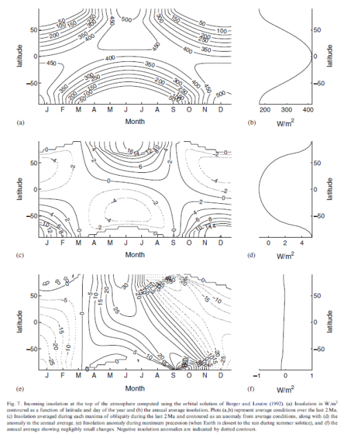
As a result of lots of careful work by innumerable people over many decades, out popped a paper by Hays, Imbrie & Shackleton in 1976. This demonstrated that a lot of the recorded changes in ice volume happened at orbital frequencies of precession and obliquity (approximately every 20kyrs and every 40 kyrs). But there was an even stronger signal – the start and end of ice ages – at approximately every 100 kyrs. This coincides roughly with changes in eccentricity of the earth’s orbit, not that anyone has a (viable) theory that links this change to the start and end of ice ages.

Now the clear signal of obliquity and precession in the record gives us the option of “tuning up” the record so that peaks in the record match orbital frequencies of precession and obliquity. We discussed the method of tuning in some past comments on a similar, but much later, dataset – the LR04 stack (thanks to Clive Best for highlighting it).

The method isn’t wrong, but we can’t confirm the timing of key events with a dataset where dates have been tuned to a specific theory.

Luckily, some new methods have come along.

Ice Core Dating

It’s been exciting times for the last twenty plus years in climate science for people who want to wear thick warm clothing and “get away from it all”.

Greenland and Antarctica have yielded a number of ice cores. Greenland now has a record that goes back 123,000 years (NGRIP). Antarctica now has a record that goes back 800,000 years (EDC, aka, “Dome C”). Antarctica also has the Voskok ice core that goes back about 400,000 years, Dome Fuji that goes back 340,000 years and Dronning Maud Land (aka DML or EDML) which is higher resolution but only goes back 150,000 years.

What do these ice cores measure and how is the dating done?

The ice cores measure temperature at time of snow deposition via the δ18O measurement discussed above (note 2), which in this case is not a measure of global ice volume but of air temperature. The gas trapped in bubbles in the ice cores gives us CO2 and CH4 concentrations. We also can measure dust deposition and all kinds of other goodies.

The first problem is that the gas is “younger” than the ice because it moves around until the snow compacts enough. So we need a model to calculate this, and there is some uncertainty about the difference in age between the ice and the gas.

The second problem is how to work out the ice age. At the start we can count annual layers. After sufficient time (a few tens of thousands of years) these layers can’t be distinguished any more, instead we can use models of ice flow physics. Then a few handy constraints arrive like 10Be events that occurred about 50 kyrs BP. After ice flow physics and external events are exhausted, the data is constrained by “orbital tuning”, as with deep ocean cores.

Caves, Corals and Accurate Radiometric Dating

Neither deep sea cores, nor ice cores, give us much possibility of radiometric dating. But caves and corals do.

For newcomers to dating methods, if you have substance A that decays into substance B with a “half-life” that is accurately known, and you know exactly how much of substance A and B was there at the start (e.g. no possibility of additional amounts of A or B getting into the thing we want to measure) then you can very accurately calculate the age that the substance was formed.

Basically it’s all down to how to deposition process works. Uranium-Thorium dating has been successfully used to date calcite depositions in rock.

So, take a long section that has been continuously deposited, measure the δ18O (and 13C) at lots of points along the section, and take a number of samples and calculate the age along the section with radiometric dating. The subject of what exactly is being measured in the cores is complicated, but I will greatly over-simplify and say it revolves around two points:

  1. The actual amount of deposition, as not much water is available to create these depositions during extreme glaciation
  2. The variation of δ18O (and 13C), which to a first order depends on local air temperature

For people interested in more detail, I recommend McDermott 2004, some relevant extracts below in note 3).

Corals offer the possibility, via radiometric dating, of getting accurate dates of sea level. The most important variable to know is any depression and uplift of the earth’s crust.

Accurate dating of caves and coral has been a growth industry in the last twenty years with some interesting results.

Termination II

Winograd et al 1992 analyzed Devils Hole in Nevada (DH-11):

The Devils Hole δ18O time curve (fig 2) clearly displays the sawtooth pattern characteristic of marine δ18O records that have been interpreted to be the result of the waxing and waning of Northern Hemisphere ice sheets.. But what caused the δ18O variations in DH-11 shown on fig. 2? ..The δ18O variations in atmospheric precipitation are – to a first approximation – believed to reflect changes in average winter-spring surface temperature..

From Winograd et al 1992

From Winograd et al 1992

Figure 2

Termination II occurs at 140±3 (2σ) ka in the DH-11 record, at 140± 15 ka in the Vostok record (14), and at 128 ± 3 ka in the SPECMAP record (13). (The uncertainty in the DH-11 record is in the 2σ uncertainties on the MS uranium-series dates; other dates and uncertainties are from the sources cited.) Termination III occurred at about 253 +/- 3 (2σ) ka in the DH11 record and at about 244 +/- 3 ka in the SPECMAP record. These differences.. are minimum values..

They compare summer insolation at 65ºN with SPECMAP, Devils Hole and the Vostok ice core on a handy graph:

Winograd et al 1992

Winograd et al 1992

Figure 3

Of course, not everyone was happy with this new information, and who knows what the isotope measurement really was a proxy for?

Slowey, Henderson & Curry 1996

A few years later, in 1996, Slowey, Henderson & Curry (not the famous Judith) made this statement from their research:

Our dates imply a timing and duration for substage 5e in substantial agreement with the orbitally tunes marine chronology. Initial direct U-Th dating of the marine δ18O record supports the theory that orbital variations are a fundamental cause of Pleistocene climate change.

[Emphasis added, likewise with all quotes].

Henderson & Slowey 2000

Then in 2000, the same Henderson & Slowey (sans Curry):

Milankovitch proposed that summer insolation at mid-latitudes in the Northern Hemisphere directly causes the ice-age climate cycles. This would imply that times of ice-sheet collapse should correspond to peaks in Northern Hemisphere June insolation.

But the penultimate deglaciation has proved controversial because June insolation peaks 127 kyr ago whereas several records of past climate suggest that change may have occurred up to 15kyr earlier.

There is a clear signature of the penultimate deglaciation in marine oxygen-isotope records. But dating this event, which is significantly before the 14C age range, has not been possible.

Here we date the penultimate deglaciation in a record from the Bahamas using a new U-Th isochron technique. After the necessary corrections for a-recoil mobility of 234U and 230Th and a small age correction for sediment mixing, the midpoint age for the penultimate deglaciation is determined to be 135 +/-2.5 kyr ago. This age is consistent with some coral-based sea-level estimates, but it is difficult to reconcile with June Northern Hemisphere insolation as the trigger for the ice-age cycles.

Zhao, Xia & Collerson (2001)

High-precision 230Th- 238U ages for a stalagmite from Newdegate Cave in southern Tasmania, Australia.. The fastest stalagmite growth occurred between 129.2 ± 1.6 and 122.1 ± 2.0 ka (†61.5 mm/ka), coinciding with a time of prolific coral growth from Western Australia (128-122 ka). This is the first high-resolution continental record in the Southern Hemisphere that can be compared and correlated with the marine record. Such correlation shows that in southern Australia the onset of full interglacial sea level and the initiation of highest precipitation on land were synchronous. The stalagmite growth rate between 129.2 and 142.2 ka (†5.9 mm/ka) was lower than that between 142.2 and 154.5 ka (†18.7 mm/ka), implying drier conditions during the Penultimate Deglaciation, despite rising temperature and sea level.

This asymmetrical precipitation pattern is caused by latitudinal movement of subtropical highs and an associated Westerly circulation, in response to a changing Equator-to-Pole temperature gradient.

Both marine and continental records in Australia strongly suggest that the insolation maximum between 126 and 128 ka at 65°N was directly responsible for the maintenance of full Last Interglacial conditions, although the triggers that initiated Penultimate Deglaciation (at †142 ka) remain unsolved.

From Zhao et al 2001

From Zhao et al 2001

Figure 4

Gallup, Cheng, Taylor & Edwards (2002)

An outcrop within the last interglacial terrace on Barbados contains corals that grew during the penultimate deglaciation, or Termination II. We used combined 230Th and 231Pa dating to determine that they grew 135.8 ± 0.8 thousand years ago, indicating that sea level was 18 ± 3 meters below present sea level at the time. This suggests that sea level had risen to within 20% of its peak last- interglacial value by 136 thousand years ago, in conflict with Milankovitch theory predictions..

Figure 2B summarizes the sea level record suggested by the new data. Most significantly our record includes corals that document sea level directly during Termination II, suggesting that the majority (~80%) of the Termination II sea level rise occurred before 135 ka. This is broadly consistent with early shifts in δ18O recorded in the Bahamas and Devils Hole and with early dates (134 ka) of last interglacial corals from Hawaii, which call into question the timing of Termination II in the SPECMAP record..

From Gallup et al 2002

From Gallup et al 2002

Figure 5 – Click to expand

 Of course, all is not lost for the many-headed Hydra (and see note 4):

..The Milankovitch theory in its simplest form cannot explain Termination II, as it does Termination I. However, it is still plausible that insolation forcing played a role in the timing of Termination II. As deglaciations must begin while Earth is in a glacial state, it is useful to look at factors that could trigger deglaciation during a glacial maximum. These include – (i) sea ice cutting off a moisture source for the ice sheets; – (ii) isostatic depression of continental crust; and – (iii) high Southern Hemisphere summer insolation through effects on the atmospheric CO concentration.

Yuan et al 2004 provide evidence in opposition:

Thorium-230 ages and oxygen isotope ratios of stalagmites from Dongge Cave, China, characterize the Asian Monsoon and low-latitude precipitation over the past 160,000 years. Numerous abrupt changes in 18O/16O values result from changes in tropical and subtropical precipitation driven by insolation and millennial-scale circulation shifts.

The Last Interglacial Monsoon lasted 9.7 +/- 1.1 thousand years, beginning with an abrupt (less than 200 years) drop in 18O/16O values 129.3 ± 0.9 thousand years ago and ending with an abrupt (less than 300 years) rise in 18O/16O values 119.6 ± 0.6 thousand years ago. The start coincides with insolation rise and measures of full interglacial conditions, indicating that insolation triggered the final rise to full interglacial conditions.

But they also comment:

Although the timing of Monsoon Termination II is consistent with Northern Hemisphere insolation forcing, not all evidence of climate change at about this time is consistent with such a mechanism (Fig. 3).

From Yuan et al 2004

From Yuan et al 2004

Figure 6 – Click to expand

Sea level apparently rose to levels as high as –21 m as early as 135 ky before the present (27 & Gallup et al 2002), preceding most of the insolation rise. The half-height of marine oxygen isotope Termination II has been dated at 135 +/- 2.5 ky (Henderson & Slowey 2000).

Speleothem evidence from the Alps indicates temperatures near present values at 135 +/- 1.2 ky (31). The half-height of the d18O rise at Devils Hole (142 +/- 3 ky) also precedes most of the insolation rise (20). Increases in Antarctic temperature and atmospheric CO2 (32) at about the time of Termination II appear to have started at times ranging from a few to several millennia before most of the insolation rise (4, 32, 33).

[Their reference numbers amended to papers where cited in this article]

Drysdale et al 2009

Variations in the intensity of high-latitude Northern Hemisphere summer insolation, driven largely by precession of the equinoxes, are widely thought to control the timing of Late Pleistocene glacial terminations. However, recently it has been suggested that changes in Earth’s obliquity may be a more important mechanism. We present a new speleothem-based North Atlantic marine chronology that shows that the penultimate glacial termination (Termination II) commenced 141,000 ± 2,500 years before the present, too early to be explained by Northern Hemisphere summer insolation but consistent with changes in Earth’s obliquity. Our record reveals that Terminations I and II are separated by three obliquity cycles and that they started at near-identical obliquity phases.

Standard stuff by now, for readers who have made it this far.

But the Drysdale paper is interesting on two fronts – their dating method and their “one result in a row” matching a theory with evidence (I extracted more text from the paper in note 5  for interested readers). Let’s look at the dating method first.

Basically what they did was match up the deep ocean cores that record global ice volume (but have no independent dating) with accurately radiometrically-dated speleothems (cave depositions). How did they do the match up? It’s complicated but relies on the match between the δ18O in both records. The approach of providing absolute dating for existing deep ocean cores will give very interesting results if it proves itself.

From Drysdale et al 2009

From Drysdale et al 2009

Figure 7 – Click to expand

The correspondence between Corchia δ18O and Iberian-margin sea-surface temperatures (SSTs) through T-II (Fig. 2) is remarkable. Although the mechanisms that force speleothem δ18O variations are complex, we believe that Corchia δ18O is driven largely by variations in rainfall amount in response to changes in regional SSTs. Previous studies from Corchia show that speleothem δ18O is sensitive to past changes in North Atlantic circulation at both orbital and millennial time scales, with δ18O increasing during colder (glacial or stadial) phases and the reverse occurring during warmer (inter- glacial or interstadial) phases.

From Drysdale et al 2009

From Drysdale et al 2009

Figure 8 – Click to expand

Now to the hypothesis:

From Drysdale et al 2009

From Drysdale et al 2009

Figure 9

We find that NHSI [NH summer insolation] intensity is unlikely to be the driving force for T-II: Intensity values are close to minimum at the time of the start of T-II, and a lagged response to the previous insolation peak at ~148 ka is unlikely because of its low amplitude (Fig. 3A). This argues against the SPECMAP curve being a reliable age template through T-II, given the age offset of ~8 ky for the T-II midpoint (8) with respect to our record. A much stronger case can be made for obliquity as a forcing mechanism.

On the basis of our results (Fig. 3B), both T-I and T-II commence at the same phase of obliquity, and the period between them is exactly equivalent to three obliquity cycles (~123 ky).

(More of their explanation in note 5).

EPICA 2006

Here is my plot of the Dronning Maud Land ice core (DML) on EDC3 timescale from EPICA 2006 (data downloaded from the Nature website):

Data from EPICA

Data from EPICA

Figure 10

The many Antarctic and Greenland ice cores are still undergoing revisions of dating, and so I haven’t attempted to get the latest work. I just thought it would be good to throw in an ice core.

The value of δ18O here is a proxy for local temperature. On this timescale local temperatures began rising about 138 kyrs BP.

Conclusion

New data on Termination II from the last 20 years of radiometric dating from a number of different sites with different approaches demonstrate that TII started about 140 kyrs BP.

Here is the solar insolation curve at 65ºN over the last 180 kyrs, with the best dates of the two ice age terminations, separated by about 121 – 125 kyrs:

TOA-insolation-65N-Jul1-last-180kyrs-label-T1-T2-499px

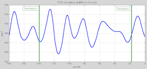
Figure – Click to expand

It’s proven that ice ages are terminated by low solar insolation in the high latitudes of the northern hemisphere. The basis for this is that the low solar insolation allows a much quicker build up of the northern hemisphere ice sheets, causing dynamic instability, leading to ice sheet calving, which disrupts ocean currents, outgassing CO2 in large concentrations and thereby creating a positive feedback for temperature rise. The local ice sheet collapses also create positive feedback due to higher solar insolation now absorbed. As the ice sheets continue to melt, the (finally) rising solar insolation in high northern latitudes strengthens the pre-existing conditions and helps to establish the termination. Thus the orbital theory is given strong support from the evidence of the timing of the last two terminations.

I just made that up in a few minutes for fun. It’s not true.

We saw one paper with different evidence for the start of TII – Yuan et al (and see note 6). However, it seems that most lines of evidence, including absolute dating of sea level rise puts TII starting around 140 kyrs BP.

This also means, for maths wizards, that the time between ice age terminations, from one result in a row, is about 122 kyrs.

As an aside, because Winograd et al 1992 calculated their age for TIII “at about 253 kyrs”:

This puts the time between TIII and TII at about 113 kyrs which is exactly the time of five precessional cycles!

I haven’t yet dug into any other dates for TIII so this theory is quite preliminary.

Articles in the Series

Part One – An introduction

Part Two – Lorenz – one point of view from the exceptional E.N. Lorenz

Part Three – Hays, Imbrie & Shackleton – how everyone got onto the Milankovitch theory

Part Four – Understanding Orbits, Seasons and Stuff – how the wobbles and movements of the earth’s orbit affect incoming solar radiation

Part Five – Obliquity & Precession Changes – and in a bit more detail

Part Six – “Hypotheses Abound” – lots of different theories that confusingly go by the same name

Part Seven – GCM I – early work with climate models to try and get “perennial snow cover” at high latitudes to start an ice age around 116,000 years ago

Part Seven and a Half – Mindmap – my mind map at that time, with many of the papers I have been reviewing and categorizing plus key extracts from those papers

Part Eight – GCM II – more recent work from the “noughties” – GCM results plus EMIC (earth models of intermediate complexity) again trying to produce perennial snow cover

Part Nine – GCM III – very recent work from 2012, a full GCM, with reduced spatial resolution and speeding up external forcings by a factors of 10, modeling the last 120 kyrs

Part Ten – GCM IV – very recent work from 2012, a high resolution GCM called CCSM4, producing glacial inception at 115 kyrs

Pop Quiz: End of An Ice Age – a chance for people to test their ideas about whether solar insolation is the factor that ended the last ice age

Eleven – End of the Last Ice age – latest data showing relationship between Southern Hemisphere temperatures, global temperatures and CO2

Twelve – GCM V – Ice Age Termination – very recent work from He et al 2013, using a high resolution GCM (CCSM3) to analyze the end of the last ice age and the complex link between Antarctic and Greenland

Fourteen – Concepts & HD Data – getting a conceptual feel for the impacts of obliquity and precession, and some ice age datasets in high resolution

Fifteen – Roe vs Huybers – reviewing In Defence of Milankovitch, by Gerard Roe

Sixteen – Roe vs Huybers II – remapping a deep ocean core dataset and updating the previous article

Seventeen – Proxies under Water I – explaining the isotopic proxies and what they actually measure

Eighteen – “Probably Nonlinearity” of Unknown Origin – what is believed and what is put forward as evidence for the theory that ice age terminations were caused by orbital changes

Nineteen – Ice Sheet Models I – looking at the state of ice sheet models

References

A Pliocene-Pleistocene stack of 57 globally distributed benthic D18O records, Lorraine E. Lisiecki & Maureen E. Raymo, Paleoceanography (2005) – free paper

Continuous 500,000-Year Climate Record from Vein Calcite in Devils Hole, Nevada, Winograd, Coplen, Landwehr, Riggs, Ludwig, Szabo, Kolesar & Revesz, Science (1992) – paywall, but might be available with a free Science registration

Palaeo-climate reconstruction from stable isotope variations in speleothems: a review, Frank McDermott, Quaternary Science Reviews 23 (2004) – free paper

Direct U-Th dating of marine sediments from the two most recent interglacial periods, NC Slowey, GM Henderson & WB Curry, Nature (1996)

Evidence from U-Th dating against northern hemisphere forcing of the penultimate deglaciation, GM Henderson & NC Slowey, Nature (2000)

Timing and duration of the last interglacial inferred from high resolution U-series chronology of stalagmite growth in Southern Hemisphere, J Zhao, Q Xia & K Collerson, Earth and Planetary Science Letters (2001)

Direct determination of the timing of sea level change during Termination II, CD Gallup, H Cheng, FW Taylor & RL Edwards, Science (2002)

Timing, Duration, and Transitions of the Last Interglacial Asian Monsoon, Yuan, Cheng, Edwards, Dykoski, Kelly, Zhang, Qing, Lin, Wang, Wu, Dorale, An & Cai, Science (2004)

Evidence for Obliquity Forcing of Glacial Termination II, Drysdale, Hellstrom, Zanchetta, Fallick, Sánchez Goñi, Couchoud, McDonald, Maas, Lohmann & Isola, Science (2009)

One-to-one coupling of glacial climate variability in Greenland and Antarctica, EPICA Community Members, Nature (2006)

Millennial- and orbital-scale changes in the East Asian monsoon over the past 224,000 years, Wang, Cheng, Edwards, Kong, Shao, Chen, Wu, Jiang, Wang & An, Nature (2008)

Notes

Note 1 – In common ice age convention, the date of a termination is the midpoint of the sea level rise from the last glacial maximum to the peak interglacial condition. This can be confusing for newcomers.

Note 2 – The alternative method used on some of the ice cores is δD, which works on the same basis – water with the hydrogen isotope Deuterium evaporates and condenses at different rates to “regular” water.

Note 3 – A few interesting highlights from McDermott 2004:

2. Oxygen isotopes in precipitation

As discussed above, d18O in cave drip-waters reflect

(i) the d18O of precipitation (d18Op) and

(ii) in arid/semi- arid regions, evaporative processes that modify d18Op at the surface prior to infiltration and in the upper part of the vadose zone.

The present-day pattern of spatial and seasonal variations in d18Op is well documented (Rozanski et al., 1982, 1993; Gat, 1996) and is a consequence of several so-called ‘‘effects’’ (e.g. latitude, altitude, distance from the sea, amount of precipitation, surface air temperature).

On centennial to millennial timescales, factors other than mean annual air temperature may cause temporal variations in d18Op (e.g. McDermott et al., 1999 for a discussion). These include:

(i) changes in the d18O of the ocean surface due to changes in continental ice volume that accompany glaciations and deglaciations;

(ii) changes in the temperature difference between the ocean surface temperature in the vapour source area and the air temperature at the site of interest;

(iii) long-term shifts in moisture sources or storm tracks;

(iv) changes in the proportion of precipitation which has been derived from non-oceanic sources, i.e. recycled from continental surface waters (Koster et al., 1993); and

(v) the so-called ‘‘amount’’ effect.

As a result of these ambiguities there has been a shift from the expectation that speleothem d18Oct might provide quantitative temperature estimates to the more attainable goal of providing precise chronological control on the timing of major first-order shifts in d18Op, that can be interpreted in terms of changes in atmospheric circulation patterns (e.g. Burns et al., 2001; McDermott et al., 2001; Wang et al., 2001), changes in the d18O of oceanic vapour sources (e.g. Bar Matthews et al., 1999) or first-order climate changes such as D/O events during the last glacial (e.g. Spo.tl and Mangini, 2002; Genty et al., 2003)..

4.1. Isotope stage 6 and the penultimate deglaciation

Speleothem records from Late Pleistocene mid- to high-latitude sites are discussed first, because these are likely to be sensitive to glacial–interglacial transitions, and they illustrate an important feature of speleothems, namely that calcite deposition slows down or ceases during glacials. Fig. 1 is a compilation of approximately 750 TIMS U-series speleothem dates that have been published during the past decade, plotted against the latitude of the relevant cave site.

The absence of speleothem deposition in the mid- to high latitudes of the Northern Hemisphere during isotope stage 2 is striking, consistent with results from previous compilations based on less precise alpha-spectrometric dates (e.g. Gordon et al., 1989; Baker et al., 1993; Hercmann, 2000). By contrast, speleothem deposition appears to have been essentially continuous through the glacial periods at lower latitudes in the Northern Hemisphere (Fig. 1)..

..A comparison of the DH-11 [Devils Hole] record with the Vostok (Antarctica) ice-core deuterium record and the SPEC- MAP record that largely reflects Northern Hemisphere ice volume (Fig. 2) indicates that both clearly record the first-order glacial–interglacial transitions.

Note 4 – Note the reference to Milankovitch theory “explaining” Termination I. This appears to be the point that insolation was at least rising as Termination began, rather than falling. It’s not demonstrated or proven in any way in the paper that Termination I was caused by high latitude northern insolation, it is an illustration of the way the “widely-accepted point of view” usually gets a thumbs up. You can see the same point in the quotation from the Zhao paper. It’s the case with almost every paper.

If it’s impossible to disprove a theory with any counter evidence then it fails the test of being a theory.

Note 5 – More from Drysdale et al 2009:

During the Late Pleistocene, the period of glacial-to-interglacial transitions (or terminations) has increased relative to the Early Pleistocene [~100 thousand years (ky) versus 40 ky]. A coherent explanation for this shift still eludes paleoclimatologists. Although many different models have been proposed, the most widely accepted one invokes changes in the intensity of high-latitude Northern Hemisphere summer insolation (NHSI). These changes are driven largely by the precession of the equinoxes, which produces relatively large seasonal and hemispheric insolation intensity anomalies as the month of perihelion shifts through its ~23-ky cycle.

Recently, a convincing case has been made for obliquity control of Late Pleistocene terminations, which is a feasible hypothesis because of the relatively large and persistent increases in total summer energy reaching the high latitudes of both hemispheres during times of maximum Earth tilt. Indeed, the obliquity period has been found to be an important spectral component in methane (CH4) and paleotemperature records from Antarctic ice cores.

Testing the obliquity and other orbital-forcing models requires precise chronologies through terminations, which are best recorded by oxygen isotope ratios of benthic foraminifera (d18Ob) in deep-sea sediments (1, 8).

Although affected by deep-water temperature (Tdw) and composition (d18Odw) variations triggered by changes in circulation patterns (9), d18Ob signatures remain the most robust measure of global ice-volume changes through terminations. Unfortunately, dating of marine sediment records beyond the limits of radiocarbon methods has long proved difficult, and only Termination I [T-I, ~18 to 9 thousand years ago (ka)] has a reliable independent chronology.

Most marine chronologies for earlier terminations rely on the SPECMAP orbital template (8) with its a priori assumptions of insolation forcing and built-in phase lags between orbital trigger and ice-sheet response. Although SPECMAP and other orbital-based age models serve many important purposes in paleoceanography, their ability to test climate- forcing hypotheses is limited because they are not independent of the hypotheses being tested. Consequently, the inability to accurately date the benthic record of earlier terminations constitutes perhaps the single greatest obstacle to unraveling the problem of Late Pleistocene glaciations..

..

Obliquity is clearly very important during the Early Pleistocene, and recently a compelling argument was advanced that Late Pleistocene terminations are also forced by obliquity but that they bridge multiple obliquity cycles. Under this model, predominantly obliquity-driven total summer energy is considered more important in forcing terminations than the classical precession-based peak summer insolation model, primarily because the length of summer decreases as the Earth moves closer to the Sun. Hence, increased insolation intensity resulting from precession is offset by the shorter summer duration, with virtually no net effect on total summer energy in the high latitudes. By contrast, larger angles of Earth tilt lead to more positive degree days in both hemispheres at high latitudes, which can have a more profound effect on the total summer energy received and can act essentially independently from a given precession phase. The effect of obliquity on total summer energy is more persistent at large tilt angles, lasting up to 10 ky, because of the relatively long period of obliquity. Lastly, in a given year the influence of maximum obliquity persists for the whole summer, whereas at maximum precession early summer positive insolation anomalies are cancelled out by late summer negative anomalies, limiting the effect of precession over the whole summer.

Although the precise three-cycle offset between T-I and T-II in our radiometric chronology and the phase relationships shown in Fig. 3 together argue strongly for obliquity forcing, the question remains whether obliquity changes alone are responsible.

Recent work invoked an “insolation-canon,” whereby terminations are Southern Hemisphere–led but only triggered at times when insolation in both hemispheres is increasing simultaneously, with SHSI approaching maximum and NHSI just beyond a minimum. However, it is not clear that relatively low values of NHSI (at times of high SHSI) should play a role in deglaciation. An alternative is an insolation canon involving SHSI and obliquity.

Note 6 – There are a number of papers based on Dongge and Hulu caves in China that have similar data and conclusions but I am still trying to understand them. They attempt to tease out the relationship between δ18O and the monsoonal conditions and it’s involved. These papers include: Kelly et al 2006, High resolution characterization of the Asian Monsoon between 146,000 and 99,000 years B.P. from Dongge Cave, China and global correlation of events surrounding Termination II; Wang et al 2008, Millennial- and orbital-scale changes in the East Asian monsoon over the past 224,000 years.

Read Full Post »

In Part Eleven we looked at the end of the last ice age. We mainly reviewed Shakun et al 2012, who provided some very interesting data on the timing of Southern Hemisphere and Northern Hemisphere temperatures, along with atmospheric CO2 values – in brief, the SH starts to heat up, then CO2 increases very close in time with SH temperatures, providing positive feedback on an initial temperature rise – and global temperatures follow SH the whole way:

From Shakun et al 2012

From Shakun et al 2012

Figure 1

This Nature paper also provided some modeling work which I had some criticism of, but it wasn’t the focus of the paper. Eric Wolff, one of the key EPICA steering committee members, also had similar criticisms of the modeling, which were published in the same Nature edition.

In this article we will look at He et al 2013, published in Nature, which is a modeling study of the same events. One of the co-authors is Jeremy Shakun, the lead author of our earlier paper. The co-authors also include Bette Otto-Bliesner, one of the lead authors of the IPCC AR5 on Paleoclimate.

For new readers, I suggest reading:

He et al 2013

Readers who have followed this series will see that the abstract (cited below) covers some familiar territory:

According to the Milankovitch theory, changes in summer insolation in the high-latitude Northern Hemisphere caused glacial cycles through their impact on ice-sheet mass balance.

Statistical analyses of long climate records supported this theory, but they also posed a substantial challenge by showing that changes in Southern Hemisphere climate were in phase with or led those in the north.

Although an orbitally forced Northern Hemisphere signal may have been transmitted to the Southern Hemisphere, insolation forcing can also directly influence local Southern Hemisphere climate, potentially intensified by sea-ice feedback, suggesting that the hemispheres may have responded independently to different aspects of orbital forcing.

Signal processing of climate records cannot distinguish between these conditions, however, because the proposed insolation forcings share essentially identical variability.

Here we use transient simulations with a coupled atmosphere–ocean general circulation model to identify the impacts of forcing from changes in orbits, atmospheric CO2 concentration, ice sheets and the Atlantic meridional overturning circulation (AMOC) on hemispheric temperatures during the first half of the last deglaciation (22–14.3 kyr BP).

Although based on a single model, our transient simulation with only orbital changes supports the Milankovitch theory in showing that the last deglaciation was initiated by rising insolation during spring and summer in the mid-latitude to high-latitude Northern Hemisphere and by terrestrial snow–albedo feedback.

[Emphasis added]. The abstract continues:

The simulation with all forcings best reproduces the timing and magnitude of surface temperature evolution in the Southern Hemisphere in deglacial proxy records.

This is a similar modeling result to the paper in Part Nine which had the same approach of individual “forcings” and a simulation with all “forcings” combined. I put “forcings” in quotes, because the forcings (ice sheets, GHGs & meltwater fluxes) are actually feedbacks, but GCMs are currently unable to simulate them.

AMOC changes associated with an orbitally induced retreat of Northern Hemisphere ice sheets is the most plausible explanation for the early Southern Hemisphere deglacial warming and its lead over Northern Hemisphere temperature; the ensuing rise in atmospheric CO2 concentration provided the critical feedback on global deglaciation.

In this paper the GCM simulations are:

  • ORB (22–14.3 kyr BP), forced only by transient variations of orbital configuration
  • GHG (22–14.3 kyr BP), forced only by transient variations of atmospheric greenhouse gas concentrations
  • MOC (19–14.3 kyr BP), forced only by transient variations of meltwater fluxes from the Northern Hemisphere (NH) and Antarctic ice sheets
  • ICE (19– 14.3 kyr BP), forced only by quasi-transient variations of ice-sheet orography and extent based on the ICE-5G (VM2) reconstruction.

And then there is an ALL simulation which combines all of these forcings. The GCM used is CCSM3 (we saw CCSM4, an updated version of CCSM3, used in Part Ten – GCM IV).

The idea behind the paper is to answer a few questions, one of which is why, if high latitude Northern Hemisphere (NH) solar insolation changes are the key to understanding ice ages, did the SH warm first? (This question was also addressed in Shakun et al 2012).

Another idea behind the paper is to try and simulate the actual temperature rises in both NH and SH during the last deglaciation.

Let’s take a look..

Their first figure is a little hard to get into but the essence is that blue is the model with only orbital forcing (ORB), red is the model with ALL forcings and black is the proxy reconstruction of temperature (at various locations).

From He et al 2013

From He et al 2013

Figure 2 

We can see that orbital forcing on its own has just about no impact on any of the main temperature metrics, and we can see that Antarctica and Greenland have different temperature histories in this period.

  • We can see that their ALL model did a reasonable job of reconstructing the main temperature trends.
  • We can also see that it did a poor job of capturing the temperature fluctuations on the scale of centuries to 1kyr when they occurred.

For reference here is the Greenland record from NGRIP from 20k – 10kyrs BP:

NGRIP-20k-10k-BP-499px

Figure 3 – NGRIP data

We can see that the main warming in Greenland (at least this location in N. Greenland) took place around 15 kyrs ago, whereas Antarctica (compare figure 1 from Shakun et al) started its significant warming around 18 kyrs ago.

The paper basically demonstrates that they can capture two main temperature trends due to two separate effects:

  1. The “cooling” in Greenland from 19k-17k years with a warming in Antarctica over the same period – due to the MOC
  2. The continued warming from 17k-15k in both regions due to GHGs

Note that my NGRIP data shows a different temperature trend from their GISP data and I don’t know why.

Let’s understand what the model shows – this data is from their Supplementary data found on the Nature website.

First, 19-17 kyrs ago, Antartica (AN) has a significant warming, while Greenland (GI) has a bigger cooling:

He et al 2013-figS25

Figure 4

Note that the MOC (yellow) is the simulation that produces both the GI and AN change. (SUM is the values of the individual runs added together, while ALL is the simulation with all forcings combined).

Second, 17 – 15 kyrs ago, Antartica (AN) continues its warming and Greenland (GI) also warms:

He et al 2013-figS27

Figure 5

Note that GHG (pink) is the primary cause of the temperature rises now.

We can see the temperature trends over time as a better way of viewing it. I added some annotations because the layout wasn’t immediately obvious (to me):

He et al 2013-fig4-annotated-499px

Figure 6 – Red/blue annotations on side, and orange annotations on top

Again, as with figure 1, we can see that the main trends are quite well simulated but the model doesn’t pick shorter period variations.

The MOC in brief

A quick explanation – the MOC brings warmer surface tropical water to the high northern latitudes, warming up the high latitudes. The cold water returns at depth, making a really big circulation. When this circulation is disrupted Antarctica gets more tropical water and warms up (Antarctica has a similar large scale circulation running from the tropics on the surface and back at depth), while the northern polar region cools down.

It’s called the bipolar seesaw.

When your pour an extremely big vat of fresh water into the high latitudes it slows down, or turns off, the MOC. This is because fresh water is not as heavy as salty water, it can’t sink and it slows down the circulation.

So – if you have lots of ice melting in the high northern latitudes it flows into the ocean, slowing down the MOC, cooling the high northern latitudes and warming up Antarctica.

That’s what their model shows.

The available data on the MOC supports the idea, here is the part d from their fig 1 – the black line is the proxy reconstruction:

He et al 2013 fig1d

Figure 7

The units on the left are volume rates of water flowing between the tropics and high northern latitudes.

What Did Orbital Forcing do in their Model?

If we look back at their figure 1 (our figure 2) we see no change to anything as a result of simulation ORB so the abstract might seem a little confusing when their paper indicates that insolation, aka the Milankovitch theory, is what causes the whole chain of events.

In their figure 2 they show a geographical look of polar and high latitude summer temperature changes as a result of simulation ORB.

The initial increase of the mid-latitude to high-latitude NH spring–summer insolation between 22 and 19 kyr BP was about threefold that in the SH (Fig. 2a, b). Furthermore, the decrease in surface albedo from the melting of terrestrial snow cover in the NH results in additional net solar flux absorption in the NH (Supplementary Figs 12–15). Consequently, NH summers in simulation ORB warm by up to 2°C in the Arctic and by up to 4°C over Eurasia, with an area average of 0.9°C warming in mid to high latitudes in the NH (Fig. 2c, e).

In their model this doesn’t affect Greenland (for reasons I don’t understand). They claim:

Our ORB simulation thus supports the Milankovitch theory in showing that substantial summer warming occurs in the NH at the end of the Last Glacial Maximum as a result of the larger increase in high-latitude spring–summer insolation in the NH and greater sensitivity of the land-dominated northern high latitudes to insolation forcing from the snow–albedo feedback.

This orbitally induced warming probably initiated the retreat of NH ice sheets and helped sustain their retreat during the Oldest Dryas.

[Emphasis added].

Analysis

1. If we run the same orbital simulation at 104, 83 or 67 kyrs BP (or quite a few other times) what would we find? Here are the changes in insolation at 60°N from 130 kyrs BP to the present:

TOA-insolation-June21-60N-130k-present-499px

Figure 8

It’s not at all clear what is special about 21-18 kyr BP insolation. It’s no surprise that a GCM produces a local temperature increase when local insolation rises.

2. The meltwater pulse injected in the model is not derived from a calculation of any ice melt as a result of increased summer temperatures over ice sheets, it is an applied forcing. Given that the ice melt slows down the MOC and therefore acts to reduce the high latitude temperature, the MOC should act as a negative feedback on any ice/snow melt.

4. The Smith & Gregory 2012 paper that we look at in Part Nine maybe has different effects from the individual forcings to those found by He et al. Because 20 – 15 kyrs is a little compressed in Smith & Gregory I can’t be sure. Take, for example, the effect on (only) ice sheets during this period. Quite an effect in SG2012 over Greenland, nothing in He et al (see fig 6 above).

From Smith & Gregory 2012

From Smith & Gregory 2012

Figure 9

Conclusion

It’s an interesting paper, showing that changes in the large scale ocean currents between tropics and poles (the MOC) can account for a Greenland cooling and an Antarctic warming roughly in line with the proxy records. Most lines of evidence suggest that large-scale ice melt is the factor that disrupts the MOC.

Perhaps high latitude insolation changes at about 20 kyrs BP caused massive ice melt, which slowed the MOC, which warmed Antarctica, which led (by mechanisms unknown) to large increases in CO2, which created positive feedback on the temperature rise and terminated the last ice age.

Perhaps CO2 increased at the same time as Antarctic temperature (see the brief section on Parrenin et al 2013 in Part Eleven), therefore raising questions about where the cause and effect lies.

To make sense of climate we need to understand why:

a) previous higher insolation in the high latitudes didn’t set off the same chain of events
b) previous temperature changes in Antarctica didn’t set off the same chain of events
c) whether the temperature changes produced in simulation ORB can account for enough ice melt seen in the MOC changes (and what feedback effect that has)

And of course, we need to understand why CO2 increased so sharply at the end of the last ice age.

Articles in the Series

Part One – An introduction

Part Two – Lorenz – one point of view from the exceptional E.N. Lorenz

Part Three – Hays, Imbrie & Shackleton – how everyone got onto the Milankovitch theory

Part Four – Understanding Orbits, Seasons and Stuff – how the wobbles and movements of the earth’s orbit affect incoming solar radiation

Part Five – Obliquity & Precession Changes – and in a bit more detail

Part Six – “Hypotheses Abound” – lots of different theories that confusingly go by the same name

Part Seven – GCM I – early work with climate models to try and get “perennial snow cover” at high latitudes to start an ice age around 116,000 years ago

Part Seven and a Half – Mindmap – my mind map at that time, with many of the papers I have been reviewing and categorizing plus key extracts from those papers

Part Eight – GCM II – more recent work from the “noughties” – GCM results plus EMIC (earth models of intermediate complexity) again trying to produce perennial snow cover

Part Nine – GCM III – very recent work from 2012, a full GCM, with reduced spatial resolution and speeding up external forcings by a factors of 10, modeling the last 120 kyrs

Part Ten – GCM IV – very recent work from 2012, a high resolution GCM called CCSM4, producing glacial inception at 115 kyrs

Pop Quiz: End of An Ice Age – a chance for people to test their ideas about whether solar insolation is the factor that ended the last ice age

Eleven – End of the Last Ice age – latest data showing relationship between Southern Hemisphere temperatures, global temperatures and CO2

Thirteen – Terminator II – looking at the date of Termination II, the end of the penultimate ice age – and implications for the cause of Termination II

Fourteen – Concepts & HD Data – getting a conceptual feel for the impacts of obliquity and precession, and some ice age datasets in high resolution

Fifteen – Roe vs Huybers – reviewing In Defence of Milankovitch, by Gerard Roe

Sixteen – Roe vs Huybers II – remapping a deep ocean core dataset and updating the previous article

Seventeen – Proxies under Water I – explaining the isotopic proxies and what they actually measure

Eighteen – “Probably Nonlinearity” of Unknown Origin – what is believed and what is put forward as evidence for the theory that ice age terminations were caused by orbital changes

Nineteen – Ice Sheet Models I – looking at the state of ice sheet models

References

Northern Hemisphere forcing of Southern Hemisphere climate during the last deglaciation, He, Shakun, Clark, Carlson, Liu, Otto-Bliesner & Kutzbach, Nature (2013) – free paper (there is considerable supplementary information probably only available on the Nature website)

Read Full Post »

In the recent articles we mostly reviewed climate models’ successes or otherwise with simulating the last glacial inception.

Part Seven looked at some early GCM work – late 80′s to mid 90′s. Part Eight reviewed four different studies a decade or so ago. Part Nine was on one study which simulated the last 120 kyrs, and Part Ten reviewed one of the most recent studies of glacial inception 115 kyrs ago with a very latest climate model, CCSM4.

We will return to glacial inception, but in this article we will look at the end of the last ice age, partly because on another blog someone highlighted a particular paper which covered it and I spent some time trying to understand the paper.

The last 20 kyrs now have some excellent records from both polar regions. The EPICA project, initiated almost 20 years ago, has produced ice core data for Antarctica to match up with the Greenland NGRIP ice core data going back almost 800 kyrs. And from other research more proxy temperature data has become available from around the globe.

Shakun et al 2012

This paper is from Shakun et al 2012 (thanks to commenter BBD for highlighting it). As an aside, Bette Otto-Bliesner is one of the co-authors, also for Jochum et al (2012) that we reviewed in Part Ten. She is one of the lead authors of the IPCC AR5 for the section on Paleoclimate.

The Last Glacial Maximum (LGM) was around 22k-18 kyrs ago. Sea level was 120m lower than today as thick ice sheets covered parts of North America and Europe.

Why did it end? How did it end?

The paper really addresses the second question.

The top graph below shows Antarctic temperatures in red, CO2 in yellow dots and global temperatures in blue:

From Shakun et al 2012

From Shakun et al 2012

Figure 1

The second graph shows us the histogram of leads and lags vs CO2 changes for both Antarctica and global temperature.

We can see clearly that the Antarctic temperatures started a sustained increase about 18 kyrs ago and led the global temperatures. We can see that CO2 is slightly preceded by, or in sync with, Antarctic temperatures. This  indicates that the CO2 increases here are providing a positive feedback on an initial Antarctic temperature rise (knowing from basic physics that more CO2 increases radiative forcing in the troposphere – see note 1).

But what caused this initial rise in Antarctic temperatures? One possibility put forward is an earlier rise in temperature in the higher northern latitudes that can be seen in the second graph below:

From Shakun et al 2012

From Shakun et al 2012

Figure 2

..An important exception is the onset of deglaciation, which features about 0.3ºC of global warming before the initial increase in CO2 ,17.5 kyr ago. This finding suggests that CO2 was not the cause of initial warming.

..Substantial temperature change at all latitudes (Fig. 5b), as well as a net global warming of about 0.3ºC (Fig. 2a), precedes the initial increase in CO2 concentration at 17.5 kyr ago, suggesting that CO2 did not initiate deglacial warming. This early global warming occurs in two phases: a gradual increase between 21.5 and 19 kyr ago followed by a somewhat steeper increase between 19 and 17.5 kyr ago (Fig. 2a). The first increase is associated with mean warming of the northern mid to high latitudes, most prominently in Greenland, as there is little change occurring elsewhere at this time (Fig. 5 and Supplementary Fig. 20). The second increase occurs during a pronounced interhemispheric seesaw event (Fig. 5), presumably related to a reduction in AMOC strength, as seen in the Pa/Th record and our modelling (Fig. 4f, g).

..In any event, we suggest that these spatiotemporal patterns of temperature change are consistent with warming at northern mid to high latitudes, leading to a reduction in the AMOC at ~19 kyr ago, being the trigger for the global deglacial warming that followed, although more records will be required to confirm the extent and magnitude of early warming at such latitudes.

The interhemispheric seesaw referred to is important to understand and refers to the relationship between two large scale ocean currents – between the tropics and the high northern latitudes and between the tropics and Antartica. (A good paper to start is Asynchrony of Antarctic and Greenland climate change during the last glacial period, Blunier et al 1998). Perhaps a subject for a later article.

Then a “plausible scenario” is presented for the initial NH warming:

A possible forcing model to explain this sequence of events starts with rising boreal summer insolation driving northern warming. This leads to the observed retreat of Northern Hemisphere ice sheets and the increase in sea level commencing, 19 kyr ago (Fig. 3a, b), with the attendant freshwater forcing causing a reduction in the AMOC that warms the Southern Hemisphere through the bipolar seesaw.

This is a poor section of the paper. I find it strange that someone could write this and not at least point out the obvious flaws in it. Before explaining, two points are worth noting:

  1. That this is described a “possible forcing model” and it’s really not the paper’s subject or apparently supported by any evidence in the paper
  2. Their model runs, fig 4c, don’t support this hypothesis – they show NH temperatures trending down over this critical period. Compare 4b and 4c (b is proxy data, c is the model). However, they don’t break out the higher latitudes so perhaps their model did show this result.
From Shakun et al 2012

From Shakun et al 2012

Figure 3

The obvious criticism of this hypothesis is that insolation (summer, 65ºN) has been a lot higher during earlier periods:

TOA-insolation-June21-65N-125k-present

Figure 4

We saw this in Ghosts of Climates Past – Pop Quiz: End of An Ice Age.

And also earlier periods of significant temperature rises in the high northern latitudes have been recorded during the last glacial period. Why were none of these able to initiate this same sequence of events and initiate an Antarctic temperature rise?

At the time of the LGM, the ice sheets were at their furthest extent, with the consequent positive feedback of the higher albedo. If a small increase in summer insolation in high northern latitudes could initiate a deglaciation, surely the much higher summer insolation at 100 kyrs BP or 82 kyrs BP would have initiated a deglaciation given the additional benefit of the lower albedo at the time.

As I was completing this section of the article I went back to the Nature website to see if there was any supplemental information (Nature papers are short and online material that doesn’t appear in the pdf paper can be very useful).

There was a link to a News & Views article on this paper by Eric Wolff. Eric Wolff is one of the key EPICA contributors, a lead author and co-author of many EPICA papers, so I was quite encouraged to read his perspective on the paper.

Many people seem convinced the Milankovitch theory is without question and not accepting it is absurd, see for example the blog discussion I referred to earlier, so it’s worth quoting extensively from Wolff’s short article:

Between about 19,000 and 10,000 years ago, Earth emerged from the last glacial period. The whole globe warmed, ice sheets retreated from Northern Hemisphere continents and atmospheric composition changed significantly. Many theories try to explain what triggered and sustained this transformation (known as the glacial termination), but crucial evidence to validate them is lacking.

On page 49 of this issue, Shakun et al use a global reconstruction of temperature to show that the transition from the glacial period to the current interglacial consisted of an antiphased temperature response of Earth’s two hemispheres, superimposed on a globally coherent warming. Ocean-circulation changes, controlling the contrasting response in each hemisphere, seem to have been crucial to the glacial termination.

Once again, a key climate scientist notes that we don’t know why the last ice age ended. As we saw in Part Six – “Hypotheses Abound” – the title explains the content..

..Some studies have proposed that changes in ocean heat transport are an essential part of glacial termination. Shakun et al. combine their data with simulations based on an ocean–atmosphere general circulation model to present a plausible sequence of events from about 19,000 years ago onwards. They propose that a reduction in the AMOC (induced in the model by introducing fresh water into the North Atlantic) led to Southern Hemisphere warming, and a net cooling in the Northern Hemisphere. Carbon dioxide concentration began to rise soon afterwards, probably owing to degassing from the deep Southern Ocean; although quite well documented, the exact combination of mechanisms for this rise remains a subject of debate. Both hemispheres then warmed together, largely in response to the rise in carbon dioxide, but with further oscillations in the hemispheric contrast as the strength of the AMOC varied. The model reproduces well both the magnitude and the pattern of global and hemispheric change, with carbon dioxide and changing AMOC as crucial components.

The success of the model used by Shakun and colleagues in reproducing the data is encouraging. But one caveat is that the magnitude of fresh water injected into the Atlantic Ocean in the model was tuned to produce the inferred strength of the AMOC and the magnitude of interhemispheric climate response; the result does not imply that the ocean circulation in the model has the correct sensitivity to the volume of freshwater input.

Shakun and colleagues’ work does provide a firm data-driven basis for a plausible chain of events for most of the last termination. But what drove the reduction in the AMOC 19,000 years ago? The authors point out that there was a significant rise in temperature between 21,500 and 19,000 years ago in the northernmost latitude band (60–90° N). They propose that this may have resulted from a rise in summer insolation (incoming solar energy) at high northern latitudes, driven by well-known cycles in Earth’s orbit around the Sun. They argue that this rise could have caused an initial ice-sheet melt that drove the subsequent reduction in the AMOC.

However, this proposal needs to be treated with caution. First, there are few temperature records in this latitude band: the warming is seen clearly only in Greenland ice cores. Second, there is at least one comparable rise in temperature in the Greenland records, between about 62,000 and 60,000 years ago, which did not result in a termination. Finally, although it is true that northern summer insolation increased from 21,500 to 19,000 years ago, its absolute magnitude remained lower than at any time between 65,000 and 30,000 years ago. It is not clear why an increase in insolation from a low value initiated termination whereas a continuous period of higher insolation did not.

In short, another ingredient is needed to explain the link between insolation and termination, and the triggers for the series of events described so well in Shakun and colleagues’ paper. The see-saw of temperature between north and south throughout the glacial period, most clearly observed in rapid Greenland warmings (Dansgaard–Oeschger events), is often taken as a sign that numerous changes in AMOC strength occurred. However, the AMOC weakening that started 19,000 years ago lasted for much longer than previous ones, allowing a much more substantial rise in southern temperature and in carbon dioxide concentration. Why was it so hard, at that time, to reinvigorate the AMOC and end this weakening?

And what is the missing ingredient that turned the rise in northern insolation around 20,000 years ago into the starting gun for deglaciation, when higher insolation at earlier times failed to do so? It has been proposed that terminations occur only when northern ice-sheet extent is particularly large. If this is indeed the extra ingredient, then the next step in unwinding the causal chain must be to understand what aspect of a large ice sheet controls the onset and persistence of changes in the AMOC that seem to have been key to the last deglaciation.

[Emphasis added].

Thanks, Eric Wolff. My summary on Shakun et al, overall – on its main subject – it’s a very good paper with solid new data, good explanations and graphs.

However, this field is still in flux..

Parrenin et al 2013

Understanding the role of atmospheric CO2 during past climate changes requires clear knowledge of how it varies in time relative to temperature. Antarctic ice cores preserve highly resolved records of atmospheric CO2 and Antarctic temperature for the past 800,000 years.

Here we propose a revised relative age scale for the concentration of atmospheric CO2 and Antarctic temperature for the last deglacial warming, using data from five Antarctic ice cores. We infer the phasing between CO2 concentration and Antarctic temperature at four times when their trends change abruptly.

We find no significant asynchrony between them, indicating that Antarctic temperature did not begin to rise hundreds of years before the concentration of atmospheric CO2, as has been suggested by earlier studies.

[Emphasis added].

Ouch. In a later article we will delve into the complex world of dating ice cores and the air trapped in the ice cores.

WAIS Divide Project Members (2013)

The cause of warming in the Southern Hemisphere during the most recent deglaciation remains a matter of debate.

Hypotheses for a Northern Hemisphere trigger, through oceanic redistributions of heat, are based in part on the abrupt onset of warming seen in East Antarctic ice cores and dated to 18,000 years ago, which is several thousand years after high-latitude Northern Hemisphere summer insolation intensity began increasing from its minimum, approximately 24,000 years ago.

An alternative explanation is that local solar insolation changes cause the Southern Hemisphere to warm independently. Here we present results from a new, annually resolved ice-core record from West Antarctica that reconciles these two views. The records show that 18,000 years ago snow accumulation in West Antarctica began increasing, coincident with increasing carbon dioxide concentrations, warming in East Antarctica and cooling in the Northern Hemisphere associated with an abrupt decrease in Atlantic meridional overturning circulation. However, significant warming in West Antarctica began at least 2,000 years earlier.

Circum-Antarctic sea-ice decline, driven by increasing local insolation, is the likely cause of this warming. The marine-influenced West Antarctic records suggest a more active role for the Southern Ocean in the onset of deglaciation than is inferred from ice cores in the East Antarctic interior, which are largely isolated from sea-ice changes.

[Emphasis added].

We see that “rising solar insolation” in any part of the world from any value can be presented as a hypothesis for ice age termination. Here “local solar insolation” means the solar insolation in the Antarctic region, compare with Shakun et al, where rising insolation (from a very low value) in the high northern latitudes was presented as a hypothesis for northern warming which then initiated a southern warming.

That said, this is a very interesting paper with new data from Antarctica, the West Antarctic Ice Sheet (WAIS) Divide ice core (WDC), where drilling was completed in 2011:

Because the climate of West Antarctica is distinct from that of interior East Antarctica, the exclusion of West Antarctic records may result in an incomplete picture of past Antarctic and Southern Ocean climate change. Interior West Antarctica is lower in elevation and more subject to the influence of marine air masses than interior East Antarctica, which is surrounded by a steep topographic slope. Marine-influenced locations are important because they more directly reflect atmospheric conditions resulting from changes in ocean circulation and sea ice. However, ice-core records from coastal sites are often difficult to interpret because of complicated ice-flow and elevation histories.

The West Antarctic Ice Sheet (WAIS) Divide ice core (WDC), in central West Antarctica, is unique in coming from a location that has experienced minimal elevation change, is strongly influenced by marine conditions and has a relatively high snow-accumulation rate, making it possible to obtain an accurately dated record with high temporal resolution.

WDC paints a slightly different picture from other Antarctic ice cores:

..and significant warming at WDC began by 20 kyr ago, at least 2,000 yr before significant warming at EDML and EDC.

..Both the WDC and the lower-resolution Byrd ice-core records show that warming in West Antarctica began before the decrease in AMOC that has been invoked to explain Southern Hemisphere warming [the references include Shakun et al 2012]. The most significant early warming at WDC occurred between 20 and 18.8 kyr ago, although a period of significant warming also occurred between 22 and 21.5 kyr ago. The magnitude of the warming at WDC before 18 kyr ago is much greater than at EDML or EDC..

From WAIS Divide Project (2013)

From WAIS Divide Project (2013)

Figure 5

We will look at this paper in more detail in a later article.

Conclusion

The termination of the last ice age is a fascinating topic that tests our ability to understand climate change.

One criticism made of climate science on many blogs is that climate scientists are obsessed with running GCMs, instead of doing “real science”, “running real experiments” and “gathering real data”. I can’t say where the balance really is, but in my own journey through climate science I find that there is a welcome and healthy obsession with gathering data, finding new sources of data, analyzing data, comparing datasets and running real experiments. The Greenland and Antarctic ice core projects, like NGRIP, EPICA and WAIS Divide Project are great examples.

On other climate blogs, writers and commenters seem very happy that climate scientists have written a paper that “supports the orbital hypothesis” without any critical examination of what the paper actually supports with evidence.

Returning to the question at hand, explaining the termination of the last ice age – the problem at the moment is less that there is no theory, and more that the wealth of data has not yet settled onto a clear chain of cause and effect. This is obviously essential to come up with a decent theory.

And any theory that explains the termination of the last ice age will need to explain why it didn’t happen earlier. Invoking “rising insolation” seems like lazy journalism to me. Luckily Eric Wolff, at least, agrees with me.

Articles in the Series

Part One – An introduction

Part Two – Lorenz – one point of view from the exceptional E.N. Lorenz

Part Three – Hays, Imbrie & Shackleton – how everyone got onto the Milankovitch theory

Part Four – Understanding Orbits, Seasons and Stuff – how the wobbles and movements of the earth’s orbit affect incoming solar radiation

Part Five – Obliquity & Precession Changes – and in a bit more detail

Part Six – “Hypotheses Abound” – lots of different theories that confusingly go by the same name

Part Seven – GCM I – early work with climate models to try and get “perennial snow cover” at high latitudes to start an ice age around 116,000 years ago

Part Seven and a Half – Mindmap – my mind map at that time, with many of the papers I have been reviewing and categorizing plus key extracts from those papers

Part Eight – GCM II – more recent work from the “noughties” – GCM results plus EMIC (earth models of intermediate complexity) again trying to produce perennial snow cover

Part Nine – GCM III – very recent work from 2012, a full GCM, with reduced spatial resolution and speeding up external forcings by a factors of 10, modeling the last 120 kyrs

Part Ten – GCM IV – very recent work from 2012, a high resolution GCM called CCSM4, producing glacial inception at 115 kyrs

Pop Quiz: End of An Ice Age – a chance for people to test their ideas about whether solar insolation is the factor that ended the last ice age

Twelve – GCM V – Ice Age Termination – very recent work from He et al 2013, using a high resolution GCM (CCSM3) to analyze the end of the last ice age and the complex link between Antarctic and Greenland

Thirteen – Terminator II – looking at the date of Termination II, the end of the penultimate ice age – and implications for the cause of Termination II

Fourteen – Concepts & HD Data – getting a conceptual feel for the impacts of obliquity and precession, and some ice age datasets in high resolution

Fifteen – Roe vs Huybers – reviewing In Defence of Milankovitch, by Gerard Roe

Sixteen – Roe vs Huybers II – remapping a deep ocean core dataset and updating the previous article

Seventeen – Proxies under Water I – explaining the isotopic proxies and what they actually measure

Eighteen – “Probably Nonlinearity” of Unknown Origin – what is believed and what is put forward as evidence for the theory that ice age terminations were caused by orbital changes

Nineteen – Ice Sheet Models I – looking at the state of ice sheet models

References

Global warming preceded by increasing carbon dioxide concentrations during the last deglaciation, Shakun, Clark, He, Marcott, Mix, Liu, Otto-Bliesner, Schmittner & Bard, Nature (2012) – free paper

Climate change: A tale of two hemispheres, Eric W. Wolff, Nature (2012)

Synchronous Change of Atmospheric CO2 and Antarctic Temperature During the Last Deglacial Warming, Parrenin, Masson-Delmotte, Köhler, Raynaud, Paillard, Schwander, Barbante, Landais, Wegner & Jouzel, Science (2013) – free paper, in submission form (rather than published form)

For interest  Valérie Masson-Delmotte is one of the two co-ordinating lead authors for AR5 for the Paleoclimate section, Frédéric Parrenin is a contributing author.

Onset of deglacial warming in West Antarctica driven by local orbital forcing, WAIS Divide Project Members, Nature (2013) – free paper

Notes

Note 1 – see for example, CO2 – An Insignificant Trace Gas? – an 8-part series on CO2, Atmospheric Radiation and the “Greenhouse” Effect – a 12-part series on how radiation interacts with the atmosphere, Visualizing Atmospheric Radiation – a 13-part series to help us get a better grasp of how this works including “does water vapor overwhelm CO2″, “is CO2 saturated” and many other questions.

Read Full Post »

In previous articles we have discussed the Milankovitch hypothesis – classically paraphrased as:

Solar insolation at 65ºN in summer determines the start and end of ice ages – with minimum summer insolation preventing snow melt at high latitudes which allows perennial snow cover, positive feedback from reflected solar radiation and the consequent growth of ice sheets.

Conversely maximum solar insolation at high latitudes causes ice sheets to melt and (with the same positive feedback effect) ends the ice age.

And “summer” is usually taken as  the insolation on June 21st even if it is a somewhat arbitrary date (we can also average over a month or the season).

So I produced a few contour plots, showing the insolation anomaly by latitude and day of year compared with the present for 8 different years between the start of the last ice age (about 115 kyrs ago) and today.

The challenge for readers is to identify which graph corresponds to the end of the last ice age. And some kind of reason why you chose that graph.

I made them a little smaller so that they could be more easily compared – just click on each set to expand.

The x-axis (left to right) is day of year, and June 21st is about day 200 (actually it is 172, thanks to Climateer for pointing this out!). The y-axis (bottom to top) is the latitude. The colors represent the same in each graph and the contour lines are 10 W/m² apart.

ice-ages-part11-A-D-499px

Figures A – D – Click for larger view

ice-ages-part11-E-H-499px

Figures E – H – Click for larger view

Articles in the Series

Part One – An introduction

Part Two – Lorenz – one point of view from the exceptional E.N. Lorenz

Part Three – Hays, Imbrie & Shackleton – how everyone got onto the Milankovitch theory

Part Four – Understanding Orbits, Seasons and Stuff – how the wobbles and movements of the earth’s orbit affect incoming solar radiation

Part Five – Obliquity & Precession Changes – and in a bit more detail

Part Six – “Hypotheses Abound” – lots of different theories that confusingly go by the same name

Part Seven – GCM I – early work with climate models to try and get “perennial snow cover” at high latitudes to start an ice age around 116,000 years ago

Part Seven and a Half – Mindmap – my mind map at that time, with many of the papers I have been reviewing and categorizing plus key extracts from those papers

Part Eight – GCM II – more recent work from the “noughties” – GCM results plus EMIC (earth models of intermediate complexity) again trying to produce perennial snow cover

Part Nine – GCM III – very recent work from 2012, a full GCM, with reduced spatial resolution and speeding up external forcings by a factors of 10, modeling the last 120 kyrs

Part Ten – GCM IV – very recent work from 2012, a high resolution GCM called CCSM4, producing glacial inception at 115 kyrs

Eleven – End of the Last Ice age – latest data showing relationship between Southern Hemisphere temperatures, global temperatures and CO2

Twelve – GCM V – Ice Age Termination – very recent work from He et al 2013, using a high resolution GCM (CCSM3) to analyze the end of the last ice age and the complex link between Antarctic and Greenland

Thirteen – Terminator II – looking at the date of Termination II, the end of the penultimate ice age – and implications for the cause of Termination II

Fourteen – Concepts & HD Data – getting a conceptual feel for the impacts of obliquity and precession, and some ice age datasets in high resolution

Fifteen – Roe vs Huybers – reviewing In Defence of Milankovitch, by Gerard Roe

Sixteen – Roe vs Huybers II – remapping a deep ocean core dataset and updating the previous article

Seventeen – Proxies under Water I – explaining the isotopic proxies and what they actually measure

Eighteen – “Probably Nonlinearity” of Unknown Origin – what is believed and what is put forward as evidence for the theory that ice age terminations were caused by orbital changes

Nineteen – Ice Sheet Models I – looking at the state of ice sheet models

Read Full Post »

In Part Nine we looked at a GCM simulation over the last 120,000 years, quite an ambitious project, which had some mixed results. The biggest challenge is simply running a full GCM over such a long time frame. To do this, the model had a reduced spatial resolution, and “speeded” up all the forcings so that the model really ran over 1,200 years.

The forcings included ice sheet size/location/height, as well as GHGs in the atmosphere. In reality these are feedbacks, but GCMs are not currently able to produce them.

In this article we will look one of the latest GCMs but running over a “snapshot” period of about 700 years. This allows full spatial resolution, but has the downside of not covering anything like a full glacial cycle. The aim here is to run the model with the orbital conditions of 116 kyrs BP to see if perennial snow cover forms in the right locations. This is a similar project to what we covered with early GCMs in Part Seven – GCM I and work from around a decade ago in Part Eight – GCM II.

The paper has some very interesting results on the feedbacks which we will take a look at.

Jochum et al (2012)

The problem:

Models of intermediate complexity.. and flux- corrected GCMs have typically been able to simulate a connection between orbital forcing, temperature, and snow volume. So far, however, fully coupled, nonflux- corrected primitive equation general circulation models (GCMs) have failed to reproduce glacial inception, the cooling and increase in snow and ice cover that leads from the warm interglacials to the cold glacial periods.

Milankovitch (1941) postulated that the driver for this cooling is the orbitally induced reduction in Northern Hemisphere summertime insolation and the subsequent increase of perennial snow cover. The increased perennial snow cover and its positive albedo feedback are, of course, only precursors to ice sheet growth. The GCMs failure to recreate glacial inception, which indicates a failure of either the GCMs or of Milankovitch’s hypothesis.

Of course, if the hypothesis would be the culprit, one would have to wonder if climate is sufficiently understood to assemble a GCM in the first place. Either way, it appears that reproducing the observed glacial–interglacial changes in ice volume and temperature represents a good test bed for evaluating the fidelity of some key model feedbacks relevant to climate projections.

The potential causes for GCMs failing to reproduce inception are plentiful, ranging from numerics on the GCMs side to neglected feedbacks of land, atmosphere, or ocean processes on the theory side. It is encouraging, though, that for some GCMs it takes only small modifications to produce an increase in perennial snow cover (e.g., Dong and Valdes 1995). Nevertheless, the goal for the GCM community has to be the recreation of increased perennial snow cover with a GCM that has been tuned to the present-day climate, and is subjected to changes in orbital forcing only.

Their model:

The numerical experiments are performed using the latest version of the National Center for Atmospheric Research (NCAR) CCSM4, which consists of the fully coupled atmosphere, ocean, land, and sea ice models..

CCSM4 is a state-of-the-art climate model that has improved in many aspects from its predecessor CCSM3. For the present context, the most important improvement is the increased atmospheric resolution, because it allows for a more accurate representation of altitude and therefore land snow cover.

See Note 1 for some more model specifics from the paper. And a long time we looked at some basics of CCSM3 – Models, On – and Off – the Catwalk – Part Two.

Limitations of the model – no ice sheet module (as with the FAMOUS model in Part Nine):

The CCSM does not yet contain an ice sheet module, so we use snow accumulation as the main metric to evaluate the inception scenario. The snow accumulation on land is computed as the sum of snowfall, frozen rain, snowmelt, and removal of excess snow. Excess snow is defined as snow exceeding 1 m of water equivalent, approximately 3–5 m of snow.

This excess snow removal is a very crude parameterization of iceberg calving, and together with the meltwater the excess snow is delivered to the river network, and eventually added to the coastal surface waters of the adjacent ocean grid cells. Thus, the local ice sheet volume and the global fresh- water volume are conserved.

Problems of the model:

Another bias relevant for the present discussion is the temperature bias of the northern high-latitude land. As discussed in the next section, much of the CCSM4 response to orbital forcing is due to reduced summer melt of snow. A cold bias in the control will make it more likely to keep the summer temperature below freezing, and will overestimate the model’s snow accumulation. In the annual mean, northern Siberia and northern Canada are too cold by about 1ºC–2ºC, and Baffin Island by about 5ºC (Gent et al. 2011). The Siberian biases are not so dramatic, but it is quite unfortunate that Baffin Island, the nucleus of the Laurentide ice sheet, has one of the worst temperature biases in CCSM4. A closer look at the temperature biases in North America, though, reveals that the cold bias is dominated by the fall and winter biases, whereas during spring and summer Baffin Island is too cold by approximately 3ºC, and the Canadian Archipelago even shows a weak warm bias.

[Emphasis added, likewise with all bold text in quotes].

Their plan:

The subsequent sections will analyze and compare two different simulations: an 1850 control (CONT), in which the earth’s orbital parameters are set to the 1990 values and the atmospheric composition is fixed at its 1850 values; and a simulation identical to CONT, with the exception of the orbital parameters, which are set to the values of 115 kya (OP115). The atmospheric CO2 concentration in both experiments is 285 ppm.

The models were run for about 700 (simulated) years. They give some interesting metrics on why they can’t run a 120 kyr simulation:

This experimental setup is not optimal, of course. Ideally one would like to integrate the model from the last interglacial, approximately 126 kya ago, for 10 000 years into the glacial with slowly changing orbital forcing. However, this is not affordable; a 100-yr integration of CCSM on the NCAR supercomputers takes approximately 1 month and a substantial fraction of the climate group’s computing allocation.

Results

First of all, they do produce perennial snow cover at high latitudes.

The paper has a very good explanation of how the different climate factors go together in the high latitudes where we are looking to get perennial snow cover. It helps us see why doing stuff in your head, using basic energy balance models, and even running models of intermediate complexity (EMICs) cannot (with confidence) produce useful answers.

Let’s take a look.

Jochum et al 2012

Jochum et al 2012

Figure 1

This graph is comparing the annual solar radiation by latitude between 115 kyrs ago and today.

Incoming solar radiation –  black curve – notice the basic point that – at 115 kyrs ago the tropics have higher annual insolation while the high latitudes have lower annual insolation.

Our focus will be on the Northern Hemisphere north of 60ºN, which covers the areas of large cooling and increased snow cover. Compared to CONT [control], the annual average of the incoming radiation over this Arctic domain is smaller in OP115 by 4.3 W/m² (black line), but the large albedo reduces this difference at the TOA to only 1.9 W/m² (blue line, see also Table 1).

Blue shows the result when we take into account existing albedo – that is, because a lot of solar radiation is already reflected away in high latitudes, any changes in incoming radiation are reduced by the albedo effect (before albedo itself changes).

Green shows the result when we take into account changed albedo with the increased snow cover found in the 115 kyr simulation.

In CCSM4 this larger albedo in OP115 leads to a TOA clear-sky shortwave radiation that is 8.6 W/m² smaller than in CONT —more than 4 times the original signal.

The snow/ice–albedo feedback is then calculated as 6.7 W/m² (8.6–1.9 W/m²). Interestingly, the low cloud cover is smaller in OP115 than in CONT, reducing the difference in total TOA shortwave radiation by 3.1 to 5.5 W/m² (green line). Summing up, an initial forcing of 1.9 W/m² north of 60ºN, is amplified through the snow–ice–albedo feedback by 6.7 W/m², and damped through a negative cloud feedback by 3.1 W/m².

The summary table:

Jochum-2012-table-1

Because of the larger meridional temperature (Fig. 1a) and moisture gradient (Fig. 4a), the lateral atmospheric heat flux into the Arctic is increased from 2.88 to 3.00 PW. This 0.12 PW difference translates into an Arctic average of 3.1 W/m²; this is a negative feedback as large as the cloud feedback, and 6 times as large as the increase in the ocean meridional heat transport at 60ºN (next section).

Thus, the negative feedback of the clouds and the meridional heat transport almost compensate for the positive albedo feedback, leading to a total feedback of only 0.5 W/m². One way to look at these feedbacks is that the climate system is quite stable, with clouds and meridional transports limiting the impact of albedo changes. This may explain why some numerical models have difficulties creating the observed cooling associated with the orbital forcing.

I think it’s important to note that they get their result through a different mechanism from one of the papers we reviewed in Part Nine:

Thus, in contrast to the results of Vettoretti and Peltier (2003) the increase in snowfall is negligible compared to the reduction in snowmelt.

Their result:

The global net difference in melting and snowfall between OP115 and CONT leads to an implied snow accumulation that is equivalent to a sea level drop of 20 m in 10,000 years, some of it being due to the Baffin Island cold bias. This is less than the 50-m estimate based on sea level reconstructions between present day and 115 kya, but nonetheless it suggests that the model response is of the right magnitude.

Atlantic Meridional Overturning Current (AMOC)

This current has a big impact on the higher latitudes of the Atlantic because it brings warmer water from the tropics.

The meridional heat transport of the AMOC is a major source of heat for the northern North Atlantic Ocean, but it is also believed to be susceptible to small perturbations.

This raises the possibility that the AMOC amplifies the orbital forcing, or even that this amplification is necessary for the Northern Hemisphere glaciations and terminations. In fact, JPML demonstrates that at least in one GCM changes in orbital forcing can lead to a weakening of the MOC and a subsequent large Northern Hemisphere cooling. Here, we revisit the connection between orbital forcing and AMOC strength with the CCSM4, which features improved physics and higher spatial resolution compared to JPML.

In essence they found a limited change in the AMOC in this study. Interested readers can review the free paper. This is an important result because earlier studies with lower resolution models or GCMs that are not fully coupled have often found a strong role for the MOC in amplifying changes.

Conclusion

This is an interesting paper, important because it uses a full resolution state-of-the-art GCM to simulate perennial snow cover at 115 kys BP, simply with pre-industrial GHG concentrations and insolation from 115 kyrs BP.

The model has a cold bias (and an increased moisture bias) in high latitude NH regions and this raises questions on the significance of the result (to my skeptical mind):

  • Can a high resolution AOGCM with no high latitude cold bias reproduce perennial snow cover with just pre-industrial GHG concentration and orbital forcing from 115 kyrs ago?
  • Can this model, with its high latitude cold bias, reproduce a glacial termination?

That doesn’t mean the paper isn’t very valuable and the authors have certainly not tried to gloss over the shortcomings of the model – in fact, they have highlighted them.

What the paper also reveals – in conjunction with what we have seen from earlier articles – is that as we move through generations and complexities of models we can get success, then a better model produces failure, then a better model again produces success. Also we noted that whereas the 2003 model (also cold-biased) of Vettoretti & Peltier found perennial snow cover through increased moisture transport into the critical region (which they describe as an “atmospheric–cryospheric feedback mechanism”), this more recent study with a better model found no increase in moisture transport.

The details of how different models achieve the same result is important. I don’t think any climate scientist would disagree, but it means that multiple papers with “success” may not equate to “success for all” and may not equate to “general success”. The details need to be investigated.

This 2012 paper also demonstrates the importance of all of the (currently known) feedbacks – increased albedo from increased snow cover is almost wiped out by negative feedbacks.

Lastly, the paper also points out that their model, run over 700 years, fails to produce significant cooling of the Southern Polar region:

More importantly, though, the lack of any significant Southern Hemisphere polar response needs explaining (Fig. 1). While Petit et al. (1999) suggests that Antarctica cooled by about 10ºC during the last inception, the more recent high-resolution analysis by Jouzel et al. (2007) suggest that it was only slightly cooler than today (less than 3ºC at the European Project for Ice Coring in Antarctica (EPICA) Dome C site on the Antarctic Plateau). Of course, there are substantial uncertainties in reconstructing Antarctic temperatures..

I don’t have any comment on this particular point, lacking much understanding of recent work in dating and correlating EPICA (Antarctic ice core) with Greenland ice cores.

Articles in the Series

Part One – An introduction

Part Two – Lorenz – one point of view from the exceptional E.N. Lorenz

Part Three – Hays, Imbrie & Shackleton – how everyone got onto the Milankovitch theory

Part Four – Understanding Orbits, Seasons and Stuff – how the wobbles and movements of the earth’s orbit affect incoming solar radiation

Part Five – Obliquity & Precession Changes – and in a bit more detail

Part Six – “Hypotheses Abound” – lots of different theories that confusingly go by the same name

Part Seven – GCM I – early work with climate models to try and get “perennial snow cover” at high latitudes to start an ice age around 116,000 years ago

Part Seven and a Half – Mindmap – my mind map at that time, with many of the papers I have been reviewing and categorizing plus key extracts from those papers

Part Eight – GCM II – more recent work from the “noughties” – GCM results plus EMIC (earth models of intermediate complexity) again trying to produce perennial snow cover

Part Nine – GCM III – very recent work from 2012, a full GCM, with reduced spatial resolution and speeding up external forcings by a factors of 10, modeling the last 120 kyrs

Part Ten – GCM IV – very recent work from 2012, a high resolution GCM called CCSM4, producing glacial inception at 115 kyrs

Pop Quiz: End of An Ice Age – a chance for people to test their ideas about whether solar insolation is the factor that ended the last ice age

Eleven – End of the Last Ice age – latest data showing relationship between Southern Hemisphere temperatures, global temperatures and CO2

Twelve – GCM V – Ice Age Termination – very recent work from He et al 2013, using a high resolution GCM (CCSM3) to analyze the end of the last ice age and the complex link between Antarctic and Greenland

Thirteen – Terminator II – looking at the date of Termination II, the end of the penultimate ice age – and implications for the cause of Termination II

Fourteen – Concepts & HD Data – getting a conceptual feel for the impacts of obliquity and precession, and some ice age datasets in high resolution

Fifteen – Roe vs Huybers – reviewing In Defence of Milankovitch, by Gerard Roe

Sixteen – Roe vs Huybers II – remapping a deep ocean core dataset and updating the previous article

Seventeen – Proxies under Water I – explaining the isotopic proxies and what they actually measure

Eighteen – “Probably Nonlinearity” of Unknown Origin – what is believed and what is put forward as evidence for the theory that ice age terminations were caused by orbital changes

Nineteen – Ice Sheet Models I – looking at the state of ice sheet models

References

True to Milankovitch: Glacial Inception in the New Community Climate System Model, Jochum, Jahn, Peacock, Bailey, Fasullo, Kay, Levis & Otto-Bliesner, Journal of Climate (2012) – free paper

Notes

Note 1 – more on the model:

The ocean component has a horizontal resolution that is constant at 1.125º in longitude and varies from 0.27º at the equator to approximately 0.7º in the high latitudes. In the vertical there are 60 depth levels; the uppermost layer has a thickness of 10 m and the deepest layer has a thickness of 250 m. The atmospheric component uses a horizontal resolution of 0.9º x 1.25º with 26 levels in the vertical. The sea ice model shares the same horizontal grid as the ocean model and the land model is on the same horizontal grid as the atmospheric model.

Read Full Post »